-
24
Views -
0
Favorites
-
-
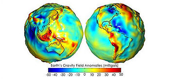
The geoid is that equipotential surface which would coincide exactly with the mean ocean surface of the Earth, if the oceans were in equilibrium, at rest (relative to the rotating Earth), and extended through the continents (such as with very narrow canals). According to C.F. Gauss, who first described it, it is the "mathematical figure of the Earth", a smooth but highly irregular surface that corresponds not to the actual surface of the Earth's crust, but to a surface which can only be known through extensive gravitational measurements and calculations. Despite being an important concept for almost two hundred years in the history of geodesy and geophysics, it has only been defined to high precision in recent decades, for instance by works of Petr Vaníček and others. It is often described as the true physical figure of the Earth, in contrast to the idealized geometrical figure of a reference ellipsoid.
The geoid surface is irregular, unlike the reference ellipsoid which is a mathematical idealized representation of the physical Earth, but considerably smoother than Earth's physical surface. Although the physical Earth has excursions of +8,000 m (Mount Everest) and −11,000 m (Mariana Trench), the geoid's total variation is less than 200 m (−106 to +85 m)[2] compared to a perfect mathematical ellipsoid.
Sea level, if undisturbed by tides, currents and weather, would assume a surface equal to the geoid. If the continental land masses were criss-crossed by a series of tunnels or narrow canals, the sea level in these canals would also coincide with the geoid. In reality the geoid does not have a physical meaning under the continents, but geodesists are able to derive the heights of continental points above this imaginary, yet physically defined, surface by a technique called spirit leveling.
-
A geodetic datum (plural datums, not data) is a reference from which measurements are made. In surveying and geodesy, a datum is a set of reference points on the Earth's surface against which position measurements are made, and (often) an associated model of the shape of the earth (reference ellipsoid) to define a geographic coordinate system. Horizontal datums are used for describing a point on the earth's surface, in latitude and longitude or another coordinate system. Vertical datums measure elevations or depths. In engineering and drafting, a datum is a reference point, surface, or axis on an object against which measurements are made.A reference datum (mathematical model) is a known and constant surface which is used to describe the location of unknown points on the earth. Since reference datums can have different radii and different center points, a specific point on the earth can have substantially different coordinates depending on the datum used to make the measurement. There are hundreds of locally-developed reference datums around the world, usually referenced to some convenient local reference point. Contemporary datums, based on increasingly accurate measurements of the shape of the earth, are intended to cover larger areas. The most common reference Datums in use in North America are NAD27, NAD83, and WGS84.
The North American Datum of 1927 (NAD 27) is "the horizontal control datum for the United States that was defined by a location and azimuth on the Clarke spheroid of 1866, with origin at (the survey station) Meades Ranch (Kansas)." ... The geoidal height at Meades Ranch was assumed to be zero. "Geodetic positions on the North American Datum of 1927 were derived from the (coordinates of and an azimuth at Meades Ranch) through a readjustment of the triangulation of the entire network in which Laplace azimuths were introduced, and the Bowie method was used." (http://www.ngs.noaa.gov/faq.shtml#WhatDatum ) NAD27 is a local referencing system covering North America.
-
The World Geodetic System is a standard for use in cartography, geodesy, and navigation. It comprises a standard coordinate frame for the Earth, a standard spheroidal reference surface (the datum or reference ellipsoid) for raw altitude data, and a gravitational equipotential surface (the geoid) that defines the nominal sea level.
The latest revision is WGS 84 (dating from 1984 and last revised in 2004), which will be valid up to about 2010.[1] Earlier schemes included WGS 72, WGS 66, and WGS 60. WGS 84 is the reference coordinate system used by the Global Positioning System.
The coordinate origin of WGS 84 is meant to be located at the Earth's center of mass; the error is believed to be less than 2 cm.[2]
-
SharpGIS | Spatial references, coordinate systems, projections, datums, ellipsoids – confusing?
Great finds
- Non Gamstop Casinos UK
- Casino Utan Spelpaus
- Best Non Gamstop Casinos Uk
- Siti Scommesse Non Aams
- Non Gamstop Casinos
- Casino Not On Gamstop
- Non Gamstop Casino
- UK Online Casinos Not On Gamstop
- Casino Non Aams Italia
- Online Casinos
- Non Gamstop Casino UK
- Casino Not On Gamstop
- Gambling Sites Not On Gamstop
- Gambling Sites Not On Gamstop
- Casinos Sin Verificación Casinos Sin Kyc
- I Migliori Casino Non Aams
- Casas De Apuesta
- Meilleur Casino En Ligne
- Meilleur Casino En Ligne Avis
- UK Casino Sites Not On Gamstop
- Casinos Not On Gamstop
- Sites Not On Gamstop
- Siti Di Casino Non Aams
- UK Casino Sites Not On Gamstop
- Casino Non Aams
- Meilleur Site Casino En Ligne Belgique
- Meilleur Site Casino En Ligne Belgique
- Siti Scommesse Non Aams Sicuri
- Sweet Bonanza Avis
- オンライン カジノ ブック メーカー
- Cresus Casino Avis
- Meilleur Casino En Ligne France


